| |
Walk from waterfront |
|
|

Eric & Patti
|
I came to Boston from Seattle in 1973 (I originally grew up in Idaho) for college and
like many of the area's students, I grew roots while I was here and never left this city, that has some of the world's best
colleges,
hospitals,
technical development,
restaurants,
neighborhoods, and the liberal policital views correspond well with mine. Boston has such a rich history and I am fascinated to see the locations of events
from America's past that took place in Boston. After high school I studied engineering for 2 years (1966-68) at University of Idaho
(here's an aerial view of my home state college) and music for 2 years (1973-75) at Berklee College of Music in Boston. I eventually studied
computers at several other schools in Metro-Boston, and after graduating in 1983 I had a great career as a computer programmer in Boston.
My wife Patti, a Nurse Practioner, and I have owned 3 homes in the suburbs since 1977. I'm retired now and we have grown
adult children who live far away (in New York City and Taiwan). We currently live in Hingham (a Boston suburb) on Otis Hill and for 35 years I took a commuter boat to Boston to get to work.

Beacon Street Apt.
|
When I first came to Boston (I still had long hair) I lived in an apartment in Brookline on Beacon Street near Cleveland Circle. I lived with a Seattle buddy, Pat Stanton, who had moved here previously and worked in Boston (Pat had been with me on my Mexico trip in 1972). I lived in that apartment for several years
while I was going to school. To get to school, or anywhere in the city on public transportation, I hopped on the Green Line MBTA trolleys, which
ran down Beacon Street with a stop in front of my building and another stop near school. I tried to take the T ("T" is short for MBTA) every day to school but I had a car and too often drove. I got lots of parking tickets,
which I never paid, and eventually my car was impounded. I owed hundreds of dollars in parking fines, probably more than the car was worth, so I let them keep the car. I quit
going to Berklee in 1975 and lived in couple of apartments in the Fenway. I lived in this apartment (1976-78)
during the notorious Blizzard of '78). Taking a break from school I worked at Beacon Auto Radiator, located across the street from Fenway Park (the Boston Red Sox baseball stadium) and a short walk from my apartment.

Suburban living
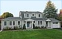
Current house
|

Previous house
|
I didn't own another car until 1977 when I needed transportation to visit my girlfriend Patti who had
moved from an apartment in Boston to a house she bought in Weymouth (I still lived in an apartment in Boston, but soon moved in with her and we got married in 1979 and we've lived in the suburbs since). After living in several
apartments in the city when I was in school, I married Patti and we've owned three suburban houses and raised 2 boys (now both college
gratuites and adults) and lived in 3 houses on the South Shore. Our first house was a Cape in Weymouth (that we lost to a fire in 1982), and the second house where we raised
the kids, was a 3-story, 10-room, shingle-style Victorian in Hingham that we bought in 1982 and lived in for 34 years, but after the kids graduated from college, started their
adult lives, and moved to other cities and we were empty-nesters for 8 years, we decided to downsize and bought a smaller house in 2015, also in Hingham (it's not
small anymore since we remodeled).

Franklin's
birthplace
|
When I was working in the city (I'm retired now but sometimes I express myself out of habit as if I am still working) I went for walks around Boston and I regularly
passed by the location of Ben Franklin's birthplace
(the building he was born in, probably a house, was located at this spot) then this office building was built there (painted black since I took my photos) which is
identified by a bust of Franklin that nobody seems to notice above the 2nd floor

Cheers |
windows of an office building just around the corner from the front of the Old South Meeting House on Washington Street
and just up the street from my office. When I was working in the Boston Financial District I went on daily walks at lunchtime with my good friend and colleague Margarette and we walked a 3-mile loop from our office that circles around the Boston
Common and Public Garden, strolling across the street from the Bull and Finch pub on Beacon Street that was the supposed setting
(shown during the theme song) of the TV show, Cheers. Starting in 1999
Margarette and I have done a 20-mile, fundraising walk, the Walk for Hunger every year. I worked for that company, Safety Insurance, for 24 years before I retired, and our company address was "20 Custom House Street", but that was a side street so the front door to the building that everybody used was on Broad Street.
I'm a long time Bostonian and I'll probably always live in Metro‑Boston. One cool thing about Boston (where I have lived most
of my life) is that jaywalking is tolerated and you can usually cross the street anywhere you can do it safely because drivers will typically yield to pedestrians. I am not recomending you step out onto a road full of
traveling cars and expect them to stop, but if the road is empty for a half-a-block you can safely proceed, and if the drivers can see you they will slow down and not run over you. I have to remember this is not true everywhere
and some locations expect (require) you to only cross the street where there is a cross walk with a lit up WALK sign.
Boston is a real walking city. With over 13 percent of its residents walking to work, more people commute by this means in Boston than in any other major American city.
Freedom Trail

 I get a feeling of pride when I notice how many people there are on the streets of Boston carrying tourist maps, knowing they have chosen to come and explore
the city where I am thrilled and privileged to be every day. I love to explore the city myself as a tourist when friends from out-of-town visit, and
I have walked the Freedom Trail a few times and discovered new things about Boston's
history, and once even went on the Boston Duck Tours with my kids.
I get a feeling of pride when I notice how many people there are on the streets of Boston carrying tourist maps, knowing they have chosen to come and explore
the city where I am thrilled and privileged to be every day. I love to explore the city myself as a tourist when friends from out-of-town visit, and
I have walked the Freedom Trail a few times and discovered new things about Boston's
history, and once even went on the Boston Duck Tours with my kids.
|
Boston Neighborhoods
 Boston: A City of Neighborhoods Boston: A City of Neighborhoods
Here are some of the neighborhoods I'm familiar with.
Downtown Crossing (Google Maps 3D)
| |

|
the intersection of Washington, Summer, and Winter streets
|
 Downtown Crossing Downtown Crossing
 Downtown Crossing through the years – longtime residents have lived through many changes Downtown Crossing through the years – longtime residents have lived through many changes
Back Bay (Google Maps)
| |
FYI, between the Public Garden and Mass. Ave. the street names are alphabetical (Arlington, Berkeley, Clarendon...)
|
| |

(Click to enlarge) |
|
"Boston Back Bay" by Sfoskett at English Wikipedia - Own work. Licensed under CC BY-SA 3.0 via Wikimedia Commons
|
A Photographic Histgory of Boston's Back Bay Neighborhood
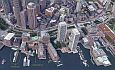
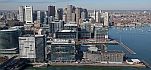
Fan Pier & Seaport (Google Maps)
| |
Fan Pier used to have freight terminals before the federal courthouse was built in 1998.
I rode past there every day on my commuter boat, so I saw the new development as it occurred.

 See the Fan Pier & Seaport development See the Fan Pier & Seaport development
(click to enlarge) |
| |
 Seaport District through the years Seaport District through the years
The Story of Fan Pier, a Catalyst for Boston's Waterfront
Why they call it Fan Pier
|
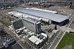
The Financial District (Google Maps)
| |
I worked here for decades.


|
| |
Financial District
- lots of good links to explore on this site
|
|
Quincy Market (Google Maps)

 not far from the building I worked in
|
|
|
Food court places:
When I was working in Boston I used to eat at these places...
| |
 Megumi of Japan – my favorite: salmon terriyaki (menu)
 Steve's Greek Cuisine – my favorite: moussaka (menu)
 Gourmet India – my favorites: chicken korma & saag paneer (menu) – I think this place is gone now!
|
| |
Boston has great theaters, where we've enjoyed seeing touring Broadway shows like
|
| |
I am retired now but for decades I worked in the Boston Financial District. The following eating places were near my office
and I went to them regularly for lunch. (Hopefully they still exist.) I believe these are primarily for office workers to grab lunch so they
might not be available on weekends, but I could be wrong and a lot of these places might be catering to tourists and always be open.
Quincy Market was located near my office, and I ate there sometimes at the food colonade.
I apologize that it is possible that some of these places may have closed since I listed them, and some of these Google Maps Street View links change.
|
 COSI –
great salads! (14 Milk Street and other locations) COSI –
great salads! (14 Milk Street and other locations)
 Flame Cafe –
a Greek and Armenian place with great a chicken gyro plate (2 Oliver Street) Flame Cafe –
a Greek and Armenian place with great a chicken gyro plate (2 Oliver Street)
Jane's Salad & Buffet (CLOSED - a favorite place, sorry to see it go) –
a Japanese buffet with Teriyaki, Tempura, and Sushi (73 Batterymarch Street)
 Boston Kebab –
Turkish and Mediterranean delights including a cold buffet and a hot buffet (7 Liberty Square / Kilby Street) Boston Kebab –
Turkish and Mediterranean delights including a cold buffet and a hot buffet (7 Liberty Square / Kilby Street)
 Lanta Asian Cuisine – Thai food, formerly Rock Sugar,
I love their Massaman Curry with Chicken (38 Batterymarch Street) Lanta Asian Cuisine – Thai food, formerly Rock Sugar,
I love their Massaman Curry with Chicken (38 Batterymarch Street)
 U&D Kitchen –
Thai cuisine (184 High Street) U&D Kitchen –
Thai cuisine (184 High Street)
Chacarero –
Chilean cuisine, the only makers of a chacarero sandwich (101 Arch Street) – I first started going to this place when it was only a cart in plaza outside Filenes
Deli One & Grill – the chicken-kabob is fabulous, and one of the few places to get an omelette!
(85 Arch Street)
 Tossed –
great salads! (One Post Office Sq on the corner of Milk & Oliver) - I think this place is gone! Tossed –
great salads! (One Post Office Sq on the corner of Milk & Oliver) - I think this place is gone!
Food trucks
| |
Another type of eating establishment that is popular are the lunch trucks that appear daily around downtown at lunchtime. There are several at
intersections or parking lots near my office in the financial district, the Boston Common, and Government Center.
You order food to go and eat it elsewhere.
|

Milk Street
|

Boston Common
|

Batterymarch
|

Govt. Center
|

Greenway
|

Dewey Square
|
Food Truck Schedule – see what trucks are where on any day

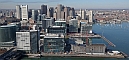
Boston Harbor
|

(read more)
|

Boston aerial
from NE
|

Skyline from boat
|

Rowes Wharf
and waterfront
|

Looking East
|

Nice aerial
|

Rowes Wharf from
commuter boat
|

Boston Light
|

View from Fan Pier
|

Friend's photo
|

My photos
|
Financial district
|
| |
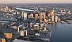
In recent decades Boston harbor has gone through a lot of changes, both
in cleaning up the water and improvements and development along the waterfront,
primarily in the Seaport District of South Boston. For years I rode a commuter boat from Hingham to Boston, so my first sight of the city each day was a spectacular view
of the harbor. An interesting feature of Boston Harbor is that Logan Airport is located
directly across the water from downtown, so one method of getting to
the airport from Boston is by water taxi from Rowes Wharf (there
used to be water shuttles that ran every 15 minutes—maybe they will come back someday). Many people traveling to the
airport from the South Shore take the commuter boat to Rowes Wharf and a water taxi to the airport, or take the ferry from Hingham, which goes directly to the airport and also
functions as a commuter boat to Long Wharf in Boston.
What's really exciting in the harbor is all the development that's happening in the Seaport District.
|
 The Boston Harbor Association The Boston Harbor Association
Seaport Hotel and Seaport World Trade Center
 Massachusetts Water Resources Authority Massachusetts Water Resources Authority
 Swimming at Boston Harbor Beaches Swimming at Boston Harbor Beaches
Tide Chart Index
 The old Northern Ave. bridge operator's house
(see actual photo) The old Northern Ave. bridge operator's house
(see actual photo)
Boston Northern Avenue Bridge Ideas Competition
Boston By Boat
 Commuter boat photos Commuter boat photos
| |
 You can take a boat from Long Wharf or Hingham to visit the islands.
|
Boston Harbor Islands National Park Area
Ten Islands – island profiles, facts, tidbits, maps
 Official Boston Harbor Islands Guides Official Boston Harbor Islands Guides
Boston Harbor Islands State Park
Friends of Boston Harbor Islands
Seaport District

Boston's Seaport District
|

Seaport location in Boston
|

Before & after
|

Historical view
|

Fan Pier & Seaport
|
Boston Convention Center
|
The Rise of the Seaport – a good description of what's going on
| |
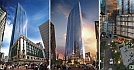
The Seaport District (aka Innovation District), the part of South Boston that borders the harbor, is getting a lot of recent development.
In all the years I worked in Boston in the Financial District
(1988-2018) it was just a funky place with old buildings and parking lots and I would occasionally walk over the Northern Avenue bridge to a few businesses until the bridge closed in 2014. Now that
area is amazingly upgraded with new high-rise buildings and restaurants, bars, retail, office space, hotels, and residences.
In August, 2019, I drove down Seaport Boulevard (a new street), and couldn't believe how changed it was. This was on a Saturday night and
there were thousands of people on the sidewalks going to new bars and restaurants.
Pre/Post-development photos
Pre-development
|
Post-development
|
|
| |
Things that are changed or gone:

Seaport piers
|

Jimmy's
Harborside
|

Anthony's
Pier 4
|

Parking lots
|
About the only original parts of this section of South Boston remaining are Commonwealth Pier
(renamed World Trade Center in 1986) and Fish Pier, former home of Boston's seafood restaurant,
No Name (it closed in 2019 but here's a video)
which had the best Seafood Chowder! (I ate at the No Name in the '70s, before it
added the 2nd floor dining room it has now).
A long-time favorite fish restaurant on Liberty Wharf, Jimmy's Harborside
closed in 2007 and has been replaced by other restaurants including
Legal Harborside (Legal Sea Foods)
and Del Frisco's Double Eagle Steak House. Another great seafood restaurant on another pier,
Anthony's Pier 4, has been demolished and new buildings are being developed on the pier that used to be a parking lot for Anthony's. The old Northern Avenue Bridge, spanning the Fort Point Channel and connecting downtown Boston with
Fan Pier, was a drivable swing bridge with
Northern Boulevard going over it, and in 1996 the fixed-span Evelyn Moakley bridge
(named after Senator Joe Moakley's wife) was built nearby with a new road, Seaport Boulevard, going over it, and the old bridge closed to
vehicles in 1999 and became a pedestrian bridge until 2014, when it was temporarily closed due to structural problems. For a long time, during its pedestrian use, it had Julian Opie's LED walking figures
 ("Suzanne walking" and "Julian walking") mounted on it. My
commuter boat docked nearby and I was amused by these figures in motion. They were sponsored by the ICA,
where Opie had an exhibit in 2005-2006, and they were removed some time after that. Hopefully it will reopen for the many people who
walked across it daily to their jobs in the Seaport District. Decades ago—before Fan Pier devolopment—I remember driving into Boston and
parking my car in a parking lot on Fan Pier and walking across that bridge to get to work in the Financial District (and even driving across it occasionally). Those parking lots are long gone. ("Suzanne walking" and "Julian walking") mounted on it. My
commuter boat docked nearby and I was amused by these figures in motion. They were sponsored by the ICA,
where Opie had an exhibit in 2005-2006, and they were removed some time after that. Hopefully it will reopen for the many people who
walked across it daily to their jobs in the Seaport District. Decades ago—before Fan Pier devolopment—I remember driving into Boston and
parking my car in a parking lot on Fan Pier and walking across that bridge to get to work in the Financial District (and even driving across it occasionally). Those parking lots are long gone.
Fan Pier (section of Seaport near bridge)
| |

Map
|

Old waterfront
(Fan Pier marked)
|

About 1920
|

As rail yard
|

Federal Courthouse
|

Under development
|

Development
slideshow
|
|
Boston memories

Trolleys
|

John Hancock
"Plywood Palace"
|

Gas tank with
Rainbow Swash
|

Kenmore Square
|

Fenway Park
|

Harvard Square
|

John Hancock
Observatory
|

FAO Schwartz Bear
|
Seaport
development
|

Filenes
|

Hancocks
Old & New
|
| |
I have lived in Metro-Boston since I came here for college in 1973 (see more at Berklee days).
"More than a feeling", a wonderful article in
The Boston Globe Magazine by a writer who's early memories of Boston are similar to mine,
contained the rhyme at the top of this page that corresponds to the weather forecasting light on top of the Old John Hancock building. In 1972, the year before I came to Boston, the old Hancock
building had become overshadowed by the new, all glass John Hancock Tower (history),
and the new building was having problems with windows falling out and crashing onto the streets below. Until
the problem was solved there were many sheets of plywood replacing missing panes of glass and the building was referred to as the "Plywood Palace." Twenty years
later Robert Campbell, the Pulitzer Prize winning architecture critic of The Boston Globe, wrote a great article about all this in the
Globe, "Builder Faced Bigger Crisis Than Falling Windows,"
and he also described the problems that occurred when the foundation for the tower, which was built in the ground fill of the Back Bay,
created structural problems for Trinity Church across the street. Once in the mid-70s when

Kenmore
Square
|
I was in Copley Square I stepped inside Trinity Church to look around, and the treasurer of the church happened to be there and he showed me
that if I stood in a particular spot and looked up into the corner of the room I could see the sky outside because the walls had separated from
the stress of the Hancock construction. The Campbell article also has a good description of the damper system used in the tower to prevent the
building from swaying too much in the wind. Because of its central location, the observatory on the
60th floor of the tower, still the tallest building in New England, provides some of the best aerial views of Boston, but unfortunately it has
been closed since 9/11. There are plans for a new
Observatory at the top of the Prudential building. (There is more
about recent changes of the Hancock Tower here.) On the right is a view of Kenmore Square (my last apartment in the 70s was near here) showing the Mass. Ave. bridge going over the
Charles River to Cambridge.
|
Commuting
| |
Since 1978 I have lived in the Boston suburbs and commuted to my jobs. Before that I had lived in the Fenway and walked to my job across from
Fenway Park, but after I moved to Weymouth to live with Patti (my wife since 1979) I drove to work in Boston,
usually on the Southeast Expressway (Route 3). Then I worked in South Boston for a few years and sometimes drove all the way in on the Expressway and sometimes drove to Quincy
Center and took the Red Line train. When I got out of school in 1983 my first programming job was on Newbury St. so I started taking the boat from Hingham. Then I took a job
at ADP in Waltham and drove up 128 (now I-95). It was a terrible rush hour commute up Route 128 to
Waltham.Then I worked in Cambridge for a few years and drove up the Expressway and took the Mass. Pike to Alston (I have a transponder in my car for tolls). Next job was in
Norwell, where I drove 10 minutes from my home in Hingham. Since 1988 all my jobs were in the Financial District in Boston until I retired in 2018 so I was a regular boat commuter. I bought a monthly T pass for the boat and a monthly parking lot pass at the shipyard where I caught the boat. Those days are over.
|
| |
 There is a multi-lane highway that goes around Boston called Route 128, "America's Technology Highway". It goes
from Gloucester down to Braintree where it ends at Route 3 South. Originally designed in 1927 the highway was completed in 1956. I-95 was originally planned to continue North through Boston but stops at 128 in Canton. I-95
continues North from Peabody (we pronouce that "PEE'-bdee") up to Maine. In 1984 the section of 128 from I-95 in Canton to I-95 North in Peabody became I-95, so I-95, which goes from Florida to Maine, continues non-stop
through Massachusetts.
There is a multi-lane highway that goes around Boston called Route 128, "America's Technology Highway". It goes
from Gloucester down to Braintree where it ends at Route 3 South. Originally designed in 1927 the highway was completed in 1956. I-95 was originally planned to continue North through Boston but stops at 128 in Canton. I-95
continues North from Peabody (we pronouce that "PEE'-bdee") up to Maine. In 1984 the section of 128 from I-95 in Canton to I-95 North in Peabody became I-95, so I-95, which goes from Florida to Maine, continues non-stop
through Massachusetts.
I live in Hingham (on the South Shore) and worked in Waltham for one job and drove up 128, which was a
terrible, bumper-to-bumper commute. After I started working in Boston I took the ferry from Hingham to Boston for 35 years until I retired.
|
Last Days of Scollay Square: 1940 - 1960
– great photos
| |

Before
|

Now
|
A rather ugly parking garage in Post Office Square was replaced in 2009 by a beautiful park, Post Office Square Park.
|
| Famous Boston restaurants that have closed |
| |
These are restaurants that I have been to and have closed in my lifetime and their years of business.
- No Name (1917-2019)
- Jimmy's Harborside (1915-2005)
- Anthony's Pier 4 (1963-2013)
- Durgin-Park (1827-2019)
- L'Espalier (1978-2018)
|
| |
 We had a snowstorm in 1978 that dumped 3 feet of snow on Boston in 36 hours, totally shutting down the city for days. I took a series of photos which I have since scanned and put on my website. When I first created this Blizzard of '78
section on my Boston page, I mentioned having photos I had taken of the storm that I would be posting someday. I was contacted by Bostonia,
the alumni magazine of Boston University (my wife Patti's alma mater), about the possibility of using some of these in their
Spring 2003 issue's Blizzard of '78 25th anniversary article. Unfortunately, I didn't locate my photos before they went to press. Since then I have been
provided with another chance to get my photos in print, and get my 15 minutes of fame!
We had a snowstorm in 1978 that dumped 3 feet of snow on Boston in 36 hours, totally shutting down the city for days. I took a series of photos which I have since scanned and put on my website. When I first created this Blizzard of '78
section on my Boston page, I mentioned having photos I had taken of the storm that I would be posting someday. I was contacted by Bostonia,
the alumni magazine of Boston University (my wife Patti's alma mater), about the possibility of using some of these in their
Spring 2003 issue's Blizzard of '78 25th anniversary article. Unfortunately, I didn't locate my photos before they went to press. Since then I have been
provided with another chance to get my photos in print, and get my 15 minutes of fame!
|
| |
 Another event that occurred in my Boston life in the seventies was my
wedding to Patti in 1979. We were married in an antique house in Waltham named "The Vale" (the Lyman Estate). We had previously been to a wedding in this beautiful house in the fall, and
decided that it was where we wanted to have our wedding, but when we got married in July the temperatures were in the 90s, and we couldn't use
the unair-conditioned house for much more than a setting for photos. All wedding activities were outside under a big canvas tent. "The Europeans," a British film starring Lee Remick, was filmed at The
Vale (this was released in 1979 so it was probably filmed not long before our July wedding). Someone else married at The Vale took these great photos of the house. Another event that occurred in my Boston life in the seventies was my
wedding to Patti in 1979. We were married in an antique house in Waltham named "The Vale" (the Lyman Estate). We had previously been to a wedding in this beautiful house in the fall, and
decided that it was where we wanted to have our wedding, but when we got married in July the temperatures were in the 90s, and we couldn't use
the unair-conditioned house for much more than a setting for photos. All wedding activities were outside under a big canvas tent. "The Europeans," a British film starring Lee Remick, was filmed at The
Vale (this was released in 1979 so it was probably filmed not long before our July wedding). Someone else married at The Vale took these great photos of the house.
|
| |
 Since 1982 we have lived in Hingham, a Boston suburb. I lived in
apartments in Brookline and Boston when I was in college, but since 1977 Patti and I have lived in suburbs, originally Weymouth, then Hingham. Before
I retired I worked in Boston's Financial District and took a commuter boat to the city every day. Patti, who's a Nurse Practitioner, works in a couple of clinics in
Dorchester owned by Harbor Health.
Since 1982 we have lived in Hingham, a Boston suburb. I lived in
apartments in Brookline and Boston when I was in college, but since 1977 Patti and I have lived in suburbs, originally Weymouth, then Hingham. Before
I retired I worked in Boston's Financial District and took a commuter boat to the city every day. Patti, who's a Nurse Practitioner, works in a couple of clinics in
Dorchester owned by Harbor Health.
|
Boston buildings & settings
|
|

Old State House
|
| |
Boston tries to preserve its history as well as promote new development, so you can walk around
downtown and see skyscrapers right next to buildings and cemeteries dating back to the 1600s. The routes of some of the streets are centuries
old, originally having only foot, cart, and animal traffic, which causes them to be pretty narrow and windy (giving directions can be a real
challenge).
|
|
|
People are probably most familiar with the local buildings that are famous from the War for Independence, which you can see by walking
the Freedom Trail, but there are other buildings, some not quite so
old, that are also of historical interest. Much of the recent development and new buildings are in the Seaport district.
|
Financial District
| |

|
|
As I have said before I am retired now, but I used to work in a building in the Financial District in downtown Boston that is identified in this photo. (Here's the front door
to the building on Broad Street.) That grassy area in the photo is the Rose Kennedy Greenway where there used to be an elevated highway called the
Central Artery a few years ago in a project named the Big Dig that was the most expensive highway
project in the history of the country. The Central Artery is now underground in a tunnel.
|
International Place
| |

|
|
International Place, built in 1992, is made up of 2 buildings, One International and Two International. I remember walking
by the site when they were preparing to blow up the building that was there before, and watching the construction was quite interesting. I have
only been in the lobby of the connected buildings and once, when I was taking photos I was asked to stop or my camera would be confiscated
for security reasons (this was after 9/11).
|
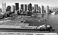
Rowes Wharf
| |

|
|
I used to take a ferry to work every day from my home in Hingham that docked at Rowes Wharf in Boston, on the edge of The Financial District. I started doing this in 1983 and it is the best commute to Boston
from the South Shore (suburbs South of Boston). I had a monthly pass for the MBTA (Boston's
transit system) that worked on the commuter rail on the rare occasions when the boats are not operating, and a monthly pass for the parking lot where I caught the boat. When I was first taking the boat Rowes Wharf was
not developed and the area was very industrial with no shelter (it is now quite elaborate with a hotel,
ferry terminal, and other things). I
used to walk under the elevated Central Artery, but since the Big Dig, when the highway was put underground, I was able to walk across the Rose Kennedy Greenway.
|
Custom House tower
| |

|
|
The site was purchased on September 13, 1837. Construction of a custom house was authorized by U.S. President Andrew Jackson. Originally only the lower portion existed. By 1905, increased shipping required the building's
expansion. In 1913-1915, the architecture firm Peabody and Stearns added the tower to the base. Although Boston at that time had a 125 ft. height
restriction, the Custom House was federally owned and exempt from it. The new tower's 496 ft. made it the city's tallest. In 1947, the Old John Hancock Building, just one foot shorter, joined it in the skies
over Boston. It now has 87 one-bedroom suites with 22 different floor plans. Amenities included a private lounge, exercise area and game room and a refurbished observation deck on the tower's 26th floor. A rotunda-level
maritime museum and exhibit room are among the public spaces that occupy the newly refurbished ground floor. In 1964, it was exceeded by the Prudential Tower (at 749 feet with 52 floors).
|
Harbor Towers
| |

|
|
Boston's first waterfront, luxury, high-rise condos, these buildings have oversized windows allowing residents to enjoy amazing views of Boston Harbor. The location of
the buildings makes Legal Seafood and the New England Aquarium within walking distance. I would see these buildings every day when I got off my commuter boat at Rowes Wharf, which was right next door.
|
Back Bay skyscrapers
| |

|
|
3 of the tallest buildings in Boston are in the Back Bay. These are:
- John Hancock tower
- Prudential tower
- One Dalton, named after it's address
|
John Hancock tower
| |

|
|
The John Hancock Tower, a beautiful glass tower in Copley Square that
is the tallest building in New England, has been renamed to "200 Clarendon" (its address) since John Hancock Insurance, whom the
building was built for, has vacated and moved to another building
in the Seaport District. Most Bostonians will always call the building by it original name, the "John Hancock Tower". Because
of its central Boston location the John Hancock Observatory in the
tower had the best views of Boston before it closed after 9/11. I was fortunate to have been there before that. The building was created in 1976 and I remember it had a problem with windows falling out. They would
replace the fallen windows with plywood and the building got the nickname "Plywood Place".
|
Trinity Church
| |

|
|
This is located in Copley Square, across the Street from the John Hancock Tower. An interesting piece of trivia—I was once in the Trinity
Church, and was shown by the treasurer of the church, who happened to be there that day, that because the Hancock building was built on
landfill it caused cracks in the church and if you stood in a certain place you could see the walls had separated in the corner of the church.
This probably resulted in lawsuits.
|
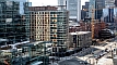
Millenium Tower
| |
|
|
The Millenium Tower, a residential skyscraper that was built attached to the old
Filene's building on Washington Street, is one of the newest buildings in Downtown Crossing. My friend Margarette and I
walked by this every day and witnessed the construction. One interesting aspect of this building is that the intersection of Washington Street and
Franklin Street used to be one of the hottest in downtown Boston on a summer day because it was in the sun all day, but now it is in the shade
and much cooler.
|

View from Common
|
Old Corner Bookstore
|

|
This building is a Boston Landmark and is listed on the National Register of Historic Places. It started out as a bookstore
and has gone through many uses, and is currently a Chipotle Mexican Grill.
|
Ames Building
Winthrop Building
|

|
The Winthrop ;Building, built in 1893, the first steel frame "skyscraper" constructed in Boston. You can stand in one spot on
Washington Street and in one direction see the Ames Building, one of the last of the old style (load bearing-wall) buildings in Boston, and in
the other direction the Winthrop Building, the first of a new style (steel-frame).
|
Boston's tallest buildings
Tallest Buildings in Boston
Existing and Proposed Buildings
List of tallest buildings in Boston
 Boston's Tallest Buildings (SkyscraperPage.com) Boston's Tallest Buildings (SkyscraperPage.com)
| |
Here are some links to photos and images of Boston buildings. See more below under Sightseeing.

|
 A View on Cities - Boston A View on Cities - Boston
Boston Buildings – photos & stats of individual buildings
Boston Pictures & Travel Journal – by Keith Stanley
Boston Skyscrapers – from Skyscraper Picture Collection
Boston Images – paintings of Boston settings
HelloBoston.com
 Boston Aerials Photo Gallery by Della Huff – beautiful photos here Boston Aerials Photo Gallery by Della Huff – beautiful photos here
tree view
many, many more pages of photos here
Then and Now: Building Boston's skyline
Financial District - lots of
building links under Notable Buildings
| 2 |
In his article Urban Scrawl,
Boston Globe architecture critic, Robert Campbell, says Boston's obsession with
history may be stifling new architecture.
|
Boston accents
(and terms) |
 click on image to hear a classic "Bawstin" accent
|
|
| |
(Doahchestuh. You cahn't get theyah from heah.)
When I first came to Boston, as a newcomer to the Northeast I had to adjust to the local accent (chowder is pronounced "chowdah"). Then I had to
learn the local vocabulary, which (sadly) has become somewhat watered-down over the last few decades with words used throughout the rest of the
country, probably because so many of us outsiders have chosen to live here. Shelley Murphy of The Boston Globe,
is a native Bostonian with a true Boston accent. 
| Here are videos with some good examples of Boston accents. |

Boston city councilor
|

Whatayou, retahdid?
|

Boston Sports Nuts
|

Parking machine
|

Good fake accents
|
Some people born and raised in Boston try to lose their distinctive accent, sometimes for professional reasons.
Shelley Murphy guide to The Boston Accent
Listen up: Just say 'ah'
Bostonspeak Primer – from an email
As heard in Boston – terms spelled with a Boston accent
 Wicked Good Guide to Boston English – Adam Gaffin's definitive glossary Wicked Good Guide to Boston English – Adam Gaffin's definitive glossary
Boston accent - Wikipedia
U.S. Regional Vocabulary Differences – has a great map showing terms for "soft drink" by county
Locals try to lose Boston accent in class – from The Boston Globe
A typical example – from Facebook
Boston accent on the Today show
| |
In Boston we have our own terms for many things which are found everywhere, and some things which are only local. A few of my favorites are:
- How to speak Boston
- tonic (soda, any carbonated soft-drink)
- frappe (a milkshake, pronounced "frap," not "frappay")
- bag (you leave a store with your purchases in a "bag," not a "sack" as they say in some parts of the country)
- rotaries (traffic circles)
- expressways (never called "freeways")
- "the T" (the MBTA, the local transit system)
For an hilarious take on the language and cultural discrepancies between the Northeast and the Midwest (or the rest of the country for that matter), see Jenna's "Culture shock" posting on her blog.
|
| |
Some of the local places have wonderful nicknames, such as:
- "Southie" (South Boston)
- "Eastie" (East Boston)
- "the Cape" (Cape Cod)
- "the Vineyard" (Martha's Vineyard, pronounced "vinyahd" with the local accent)
- "Comm Ave" (Commonwealth Avenue)
- "Mass Ave" (Massachusetts Avenue – the state name is abbreviated as "Mass" regularly in names)
- "Mass Pike" or "the Pike" (Massachusetts Turnpike)
|
| |
Sometimes we pronounce the name of a local town very differently from the way it is spelled (a good guide is
"How to Pronounce Massachusetts Town Names").
Here are some local places:
- Worcester ("WOOS'-tuh", where "oo" is the short sound in "book", not the long sound in "moon")
- Dorchester ("DOAH'-chestuh")
- Green Harbor ("Green HAH'-buh")
- Leominster ("LEM'-instuh")
- Peabody ("PEE'-bdee", not "pee'-body")
- Quincy ("QUIN'-zee", not "QUIN'-see")
- Woburn ("WOO'-burn", where "oo" is the long sound in "moon")
- Haverhill ("HAYV'-eral", the second "h" is silent)
- Scituate ("SIH'-chuat") - comes from the Indian name, Satuit
- Dedham ("DED'-um", not "ded'-ham")
- Chatham ("CHAT'-um")
- Needham ("NEED'-um")
- Hingham ("HING'-um", rhymes with "gingham") - where I live
After hearing these terms so many times over the years (since 1973) they have become part of my vocabulary. I don't think I speak with a
Boston accent, but I have been told that I do by people I knew from my youth in the Northwest. Hmmm? I'll have to ask my
muthah. I know I pronounce the names of some Western places differently than I did growing up. I now say Nevada as NEVAHDA and Colorado
as COLORAHDO, but I DON'T say OREGAHN . . . yet!
|
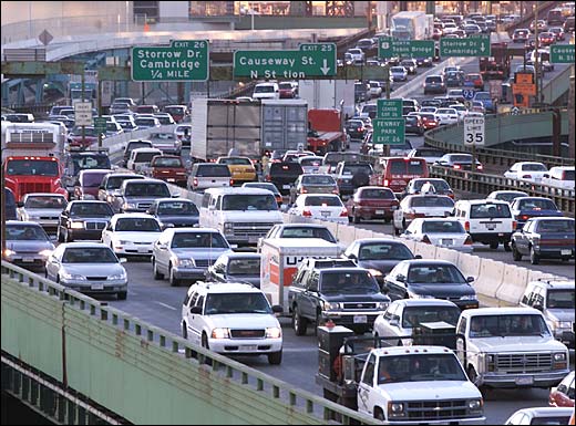
Boston driving

| |
"Survival of the fittest" summarizes the philosophy of the Boston driver, a very interesting breed. When I first drove in the
traffic here, I thought Boston had the most out of control drivers I had ever seen. Now, after decades of living here, I have
become a Boston driver and I understand the concept. In Boston, somewhat regardless of traffic laws, as a driver you are basically
on your own. Everything you encounter on your journey behind the wheel is treated with equal respect, whether it is a traffic light,
road sign, or pedestrian. What this means is that you assess what influence each object really has on you and act
accordingly, and in Boston traffic you are in a continual state of assessment and adjustment. OK, I admit it, this does tend to
raise your stress level a bit, but it might be the only way to function in our traffic, which can be pretty overwhelming. This way
of thinking also applies to pedestrians. We J-walk freely, judging our ability to cross the street safely using survival instincts,
rather than depending on Walk signs. ("Power to the people!") I think this makes us some of the most aware pedestrians
and defensive drivers anywhere. (Unfortunately, this also makes us terrors to drivers coming from elsewhere!) I think these
methods are necessary because of the volume of traffic on our inadequate roads. It often seems that if the current laws, many
written years ago when traffic was much lighter, had 100% compliance we would have eternal gridlock. When we are several cars back
from a traffic light that is turning yellow, we know we will make the light because at least 2 or 3 cars tailgate through the
intersection after every light changes to red. Sometimes it's the only way you will make that left turn. When we are the first car
waiting at a red light, after the light changes to green we always pause before proceeding to watch for drivers on the cross-street
continuing through after their light changes to red, and you must also watch the car waiting opposite you who may "bang a left" and
cut you off. Driving in a rotary is another situation with its own set of unwritten rules. By law, the car in the rotary has
the right-of-way over a car entering the rotary from a street. However, what occurs is that a car in the rotary is traveling
at a speed slow enough to manage the tight curve, whereas the car entering the rotary is driving on a straight road and could be
going 40 mph. Typically the car in the rotary yields to the faster car entering the rotary. An interesting concept in Boston driving
is that if you can make another car yield you assume the right-of-way, and usually the other driver accepts this as a normal
condition of driving here. Crazy! My advice to outsiders driving here is:
Be assertive—but also be alert and cautious.
They say if you can drive in Boston you can drive anywhere!
More information about Boston driving . . .
|
The Big Dig

|

The Greenway
Today
|

The Central Artery
Then & Now
|

The Central Artery
Going Underground
|

Atlantic Ave
before & after
|
| |
Please note: The Big Dig was finished in 2005, but I lived through it for years, so this section stays!
|
Berklee days

Berklee buildings
|
|
 From 1973-1975 I was a student at Berklee College of Music.
Previously, I had grown up in Idaho, where I started college, then lived for several years in Seattle, and this was my first experience with living in Boston, still my home (I live in Hingham, a Boston suburb).
I was a guitar player when I came to Boston but when I started at Berklee I was asked if I would consider switching to upright bass
because the school had an abundance of guitar players and a shortage of bass players. I made the switch, which turned out to be a good choice because
acoustic bass players at school were always in demand so I was frequently asked to play with people.
From 1973-1975 I was a student at Berklee College of Music.
Previously, I had grown up in Idaho, where I started college, then lived for several years in Seattle, and this was my first experience with living in Boston, still my home (I live in Hingham, a Boston suburb).
I was a guitar player when I came to Boston but when I started at Berklee I was asked if I would consider switching to upright bass
because the school had an abundance of guitar players and a shortage of bass players. I made the switch, which turned out to be a good choice because
acoustic bass players at school were always in demand so I was frequently asked to play with people.
|
|
The first time I flew on an airline was when I was a student at Berklee. I flew back to Idaho during Christmas break my freshman year.
|
Berklee campus
| |
When I went to Berklee they had just 2 buildings, the one at 1140 Boylston Street (the original building, which was the administration
building), and the newer one at 150 Mass. Ave.,
where most of the classes were held (this building also had a dorm but I lived in an apartment). In 1976 they opened up
the Berklee Performance Center on
Mass. Ave, and now they occupy all the buildings all the way down Mass. Ave. to the
Christian Science Center, including a new building at 160 Mass. Ave. and the building on the
corner of Mass. Ave. and Boylston Street that was a bank when I was at Berklee. They have expanded the campus all over the
neighborhood, here's a map.
Berklee buildings when I went there:
Some of the buildings added since I went there:
|
Music stores
| |
The music stores I frequented in those days (probably all gone now) were the Berklee store in the basement of 1140 Boylston (which later opened
up as a store on the street), Wurlitzer Music on Newbury St. in the building that became Tower Records (above the underground
Auditorium T-station), Rayburn Music on Huntington Ave. near Symphony Hall, and one on Boylston Street across from the Boston Common
(in an area named Piano Row) whose name I forget. I bought a new bow for my bass at Wurlitzer, and bought sheet music in some of
these stores to make my own "fake book," including photo-copying many lead
sheets at Berklee, until I bought my own (probably illegal) pre-printed fake-book.
|
Riding the T
| |
An interesting story about that Auditorium T-station (which has since changed its name to Hynes Convention Center). I took the T
to school and that station was a half-block from Berklee. On my rides home in the afternoon, when the train pulled into the station in rush hour
and I was standing there on the platform with my bass in a canvas case, even though the train was pretty crowded people would make room for me
with my bass because I think they were nervous around the instrument like it was fragile or something and backed away leaving me lots of room to
get on the train.
There are more Berklee memories on the Music page.
Berklee was just one of many colleges I've gone to in Boston, including MIT, Northeastern, and The Center for Computer Education (CCE) from where I graduated (that school has closed).
|
WBZ-TV anchor

(click to enlarge)
|
Jack Williams, an anchor on WBZ-TV News, was a small-town DJ
at a local radio station where I grew up in the 60s, KSRV in Ontario, Oregon (across the Snake River from my hometown,
Payette, Idaho) and he is actually from Idaho, same as me. I wasn't sure if there was an appropriate place on my website for this photo,
but it was emailed to me in 2009 by our mutual acquaintance, Bob Dye (a rock promoter in those days, he passed away in 2012), and I HAD to put it someplace.
(Jack probably wouldn't be thrilled to see this but I think it is amusing!)
|
|
|

B O S T O N L I N K S
 Favicons for sites that have them are shown next to the links.
History of Boston
Timeline
Sites of interest in Boston
History of Boston
 Historical Landmarks in Boston and Beyond Historical Landmarks in Boston and Beyond
 Mapping the 10 Buildings That Tell the Story of Boston Mapping the 10 Buildings That Tell the Story of Boston
Five Big Post-World War II Changes That Shaped Modern Boston
Full of Beans – Scot Lehigh, The Boston Globe Magazine, October 19, 2003
You know you're from Massachusetts if...
Things you should know if you're coming to Boston
You know you're from Boston when...
How Boston prepared me to travel the world – great Kate McCulley article (see more at Adventurous Kate)
Low bridge claims another truck – this happens every year when college students rent vehicles to move
How you're supposed to navigate a traffic rotary – I've driven a few rotaries in my 40+ years living in Boston
 Boston photos on Google Maps
– as you scroll through each photo you can see where it is on the map in the lower left Boston photos on Google Maps
– as you scroll through each photo you can see where it is on the map in the lower left
 The Globe Collection – black & white photos of Boston through the ages, from The Boston Globe The Globe Collection – black & white photos of Boston through the ages, from The Boston Globe
A new lease on life for Kenmore's Citgo sign – the sign was in danger when the building that hosts it was sold to a developer
 Where to Stay in Boston – a very good guide of things to see in Boston Where to Stay in Boston – a very good guide of things to see in Boston
 What makes a true Bay Stater? – I wasn't born here—but I've lived here most of my life What makes a true Bay Stater? – I wasn't born here—but I've lived here most of my life
Sightseeing
| Historical buildings & sites |

The Boston Historical Society and Museum – located at The Old State House
Historical Marker Program – includes a list of historic markers by neighborhoods
Skywalk Observatory – best views, at the top of the Prudential building (see photos)
The Paul Revere House
The Old North Church
Boston's North End Website
 Boston Tea Party Ship and Museum Boston Tea Party Ship and Museum
Where was the actual Boston Tea Party site?
 USS Constitution – aka ""Old Ironsides" USS Constitution – aka ""Old Ironsides"
Bunker Hill Monument
 Old City Hall Old City Hall
 Faneuil Hall Marketplace – (also known as Quincy Market) Faneuil Hall Marketplace – (also known as Quincy Market)
Boston History and Architecture
 Architecture of Boston, MA - Great Buildings Online Architecture of Boston, MA - Great Buildings Online
 Digital Archive of American Architecture Digital Archive of American Architecture
Architecture in Boston: Walking Tour
Walking tour 2 � Downtown Boston
Postcard Museum - Boston – buildings and places at different times
 Boston Travel Guide of Historic Sites, Attractions, Museums and much more Boston Travel Guide of Historic Sites, Attractions, Museums and much more
Site Map
Fan Pier – across the water from downtown, now under development
Master plan (pdf)
 The Boston Harborwalk The Boston Harborwalk
Retro Snapshots – Old Boston Photos and Panoramics

 John F. Kennedy Library & Museum John F. Kennedy Library & Museum
 New England Aquarium New England Aquarium
 The Children's Museum The Children's Museum
 Museum of Science Museum of Science
The Computer Museum – (now part of the Museum of Science)
 Museum of Fine Arts Museum of Fine Arts
 Isabella Stewart Gardner Museum Isabella Stewart Gardner Museum
The Museum of Afro American History
The New England Holocaust Memorial
Boston Tea Party Museum Aerial and Bird's Eye View
The Institute of Centemporary Art (ICA)
Going out

The Boston Phoenix Listings Section
Boston.com / Arts & Entertainment
Movies (find theaters by town)
Events (30 days)
Broadway In Boston
Boston.com - Arts & Entertainment
Blue Man Group – you must see this show!
American Repertory Theatre
Jambase Shows – local musical event finder
Ticketmaster
Blue Hills Bank Pavilion – formerly (Harborlights, BankBoston Pavilion, FleetBoston Pavilion, Bank of America Pavilion)
FleetCenter
Tweeter Center
Shear Madness – a hilarious whodunit!
Boston Symphony Orchestra
Boston Ballet

Boston Phoenix Restaurant Reviews
 Boston Magazine Restaurant Reviews Boston Magazine Restaurant Reviews
 Yahoo! - Boston Restaurants Yahoo! - Boston Restaurants
 CitySearch: Boston: restaurants CitySearch: Boston: restaurants
 DiningGuide Boston DiningGuide Boston
 Boston Restaurants' Menus Boston Restaurants' Menus
Portal sites and other collections

 Boston Online – check out the Wicked Good Guides Boston Online – check out the Wicked Good Guides
The Boston FAQ
Boston.com – from the Boston Globe
CitySearch: Boston
The Boston Information Server
CityBuzz Boston
Yahoo! Boston Metro
 About.com - Boston, MA About.com - Boston, MA
Digital City: Boston
 BostonHot.Com – what's HOT in Boston and the suburbs BostonHot.Com – what's HOT in Boston and the suburbs
Civic

City of Boston – the official homepage
Crossroads Initiative – some aerial photos
Back Bay Architectural District – Back Bay history
Maps of Boston – Redevelopment Authority zoning maps
 Boston Public Schools Boston Public Schools
Neighborhood maps – find a school by location
The Boston Public Library
Greater Boston Chamber of Commerce
U.S. Coast Guard Group Boston
Transportation


 "Oh,will he ever return?"
Massachusetts Department of Transportation (MassDOT)
Highway Division
Transit Division – trains, busses, boats
Registry Division (RMV)
FAST LANE – breeze through the toll booths on the Pike
MBTA – Massachusetts Bay Transportation Authority, the  – Schedules and Maps – Schedules and Maps
Subway map
CharlieCards & Tickets – name inspired by the Kingston Trio song
 MASSPORT - Logan Airport MASSPORT - Logan Airport
Arrivals
Departures
Getting to and from Logan
Boston Harbor Cruises – harbor cruises, whale watches, commuter boats
Massachusetts Bay Lines – harbor cruises, whale watches, commuter boats
Boston Transit: The MBTA – great train photos and info
SmarTraveler Boston – Boston area traffic report
Mass Highway 511 – traffic webcams
Traffic.com Boston – traffic conditions and accurate current drive times
Bostonroads.com – all about roads in the Boston area
Maps

 MapQuest Maps: Boston MapQuest Maps: Boston
Yahoo! Maps: Boston
Boston Subway Map
Boston Online - Boston maps
Maps Over Time – explore the transformation of Boston by overlaying old, new and future maps
 Microsoft TerraServer Image Page – a zoomable satellite view of Boston Microsoft TerraServer Image Page – a zoomable satellite view of Boston
MapQuest: GlobeXplorer – another zoomable satellite view of Boston
Wizeguides.com – interactive site locator
Travel Graphics – another nice locator
The Boston Atlas – a zoomable, photographic map
Islands in Boston Harbor – I got this from National Park Service
Newbury Street Map & Directory
Idaho background
| |
I grew up in Idaho, and I had gone to 2 years of college (1966-1968) at the University of Idaho (the state school where both my parents had gone—fortunately, I missed this excitement by a few years!) Then I lived in Seattle for 5 years (where, because I wasn't going to school, I lost my
2-S student-deferment draft classification and in 1969 got drafted and I refused induction), and I had take up guitar in college and played regularly, so I returned to college in Boston to study music at Berklee College of Music (1973-1975). Then I discovered computers and I went to several more schools in Boston (including M.I.T.
and Northeastern) and eventually graduated and worked for 35 years as a computer programmer until I retired in 2018. I have lived in the Boston area since 1973, and
returned to Idaho regularly to see my mother, but she died in 2017 and my Idaho connections grew very distant and I haven't been back to Idaho since my mother's funeral.
|
|

The Freedom Trail – take the Virtual Tour
Freedom Trail Map
Interactive Map – click each red light for more info
Boston Duck Tours
Swan Boats at Public Garden
 Boston By Foot - Guided Tours Boston By Foot - Guided Tours
Boston National Historical Park (National Park Service)

Wicked Good Guide to Boston Restrooms
Relief Map of Boston (Gone, but archived)
Public relief – article from The Boston Globe
Boston's High Tech Toilets
Massachusetts

Official website of the Commonwealth of Massachusetts
State Agencies
Massachusetts Judicial Branch
The 182nd General Court of Massachusetts
Senators and Representatives by City and Town
Department of Environmental Management (DEM)
Divison of Insurance
Office of Consumer Affairs
State Library
Massachusetts Area Code Map
Area Codes by town
 Department of Education Department of Education
Board of Higher Education
 Massachusetts City / Town / Locality links Massachusetts City / Town / Locality links
Cape Cod by Philip Greenspun – beautiful photographs
 Better Business Bureau Better Business Bureau
Massachusetts Office of Travel and Tourism
National Register of Historic Places: Massachusetts
Massachusetts Cultural Council
Do Not Call Registry – shut out telemarketers
 State Symbols, Facts, & Trivia State Symbols, Facts, & Trivia
Massachusetts counties
Senator Ted Kennedy's website
Senator John Kerry's website
Colleges
 (a more complete list at Boston Online)
It was college that initially brought me to Boston in 1973. I attended 5 schools here and graduated from 1. These are my schools:
-
 Berklee College of Music Berklee College of Music
- I was a jazz musician living in Seattle and read that Berklee was the best jazz school in the country so I had to go there. I was there for
2 years, 1973-1975.
The school has really grown since I was there and I would probably not even recognize it now.
- New England School of Art and Design
- I studied Interior Design, something I was apparently into at that time. The school occupied a building on the first block of Newbury Street
but has since merged with Suffolk University.
- Center for Computer Education
- I graduated from there in 1983. I was married and commuted to this school in Newton by car from my home in Hingham. The school was bought by
Grumman Data Systems and moved to New York.
- MIT (Massachusetts Institute of Technology)
- I took many programming classes there.
- Northeastern University
- I studed Java there when I was a Java programmer.
 Massachusetts Institute of Technology Massachusetts Institute of Technology
 Boston University Boston University
Boston College
 UMass Boston UMass Boston
 Northeastern University Northeastern University
 Berklee College of Music Berklee College of Music
 Harvard University Harvard University
 Tufts University Tufts University
 Emerson College Emerson College
Massachusetts College of Art
The School of the Museum of Fine Arts
Boston Architectural Center
Campus Visit Boston
Sports


 New England Patriots – the Pats dynasty won their 6th Super Bowl in 2019! New England Patriots – the Pats dynasty won their 6th Super Bowl in 2019!
|
|
| Super Bowl 2015 |

Malcom Butler
interception |

Last few minutes
of game
|

Victory Parade
|
| Super Bowl 2017 |

Julian Edelman
incredible catch |

James White
real MVP |

Victory Parade
|
|
|
Super Bowls they've played in:
- 1986
- 1997
- 2002 - Won!
- 2004 - Won!
- 2005 - Won!
- 2008 - undefeated 2007 season (16-0)
- 2012
- 2015 - Won!
- 2017 - Won!
- 2018
- 2019 - Won!
 Boston Red Sox – after an 86-year curse the Sox won the World Series in 2004, 2007, 2013, and 2018! Boston Red Sox – after an 86-year curse the Sox won the World Series in 2004, 2007, 2013, and 2018!
 Boston Celtics – the Celts have won 17 NBA Championships, most recently in 2008 (view the victory parade) Boston Celtics – the Celts have won 17 NBA Championships, most recently in 2008 (view the victory parade)
 Boston Bruins – the Bruins have won the Stanley Cup 6 times, most recently in 2011 Boston Bruins – the Bruins have won the Stanley Cup 6 times, most recently in 2011
 New England Revolution New England Revolution
 Boston Marathon Boston Marathon
Boston teams' championships
Media


The Boston Globe
 The Boston Herald The Boston Herald
The Boston Phoenix
Boston Magazine
 The Harvard Crimson The Harvard Crimson
 The Tech – MIT's web newspaper The Tech – MIT's web newspaper

 Google Maps: Boston Television Stations Google Maps: Boston Television Stations
 Boston: Television Stations Boston: Television Stations
The Boston TV Market – a list of all Boston area TV stations
 City of Boston - Film Bureau &ndash includes television City of Boston - Film Bureau &ndash includes television
| Radio (more FM streaming audio on the Music page) |

Boston Radio Archives
Boston Radio Watch – latest news on the Boston radio scene
The Archives @ BostonRadio.org
RadioBoston.com – live Internet radio
Boston Radio Stations
Webcams
 (see more webcams at Favorites and New York City)
 EarthCam - Boston Cam – a webcam view from the top of the Prudential EarthCam - Boston Cam – a webcam view from the top of the Prudential
WB56's CityCam view of Boston
WCVB's CityCam5
MMA Webcam: Corner of Temple Place & Washington St.
LiveWave: Camera Browser – Logan Airport, Boston I-93, Providence I-95, others . . .
Aberdeen LiveCam – showing Custom House Tower with airport in background
BU Alumni Web :: Web Cams
BostonHarborCam
Boston Traffic Cameras
WHDH-TV - Traffic Cams
Boston.com - Current traffic
United States Traffic Cams, others too...
 Nantucket Live Cameras Nantucket Live Cameras
The Maine Webcam Network
Mount Washington Observatory | Webcam Network
Baker Tower Camera – Dartmouth University
Other
Boston on Wikipedia – lots of information
Paul Revere
PBase.com Boston photos one of the best sites I've seen for Boston photos
 National Weather Service - Boston National Weather Service - Boston
BostonWeather.com
 Jewish Boston Online Jewish Boston Online
Greater Boston Convention & Visitors Bureau
Massachusetts Convention Center Authority
Bayside Expo Center
 Government Center – a webpage of info on the neighborhood Government Center – a webpage of info on the neighborhood
 Arnold Arboretum Arnold Arboretum
Boston Library Consortium
Citywide Reservation Services – hotels
 Welcome to Harvard Square Welcome to Harvard Square
 walkBoston – a non-profit membership organization dedicated to improving walking conditions in cities and towns across Massachusetts walkBoston – a non-profit membership organization dedicated to improving walking conditions in cities and towns across Massachusetts
 Boston MA Weather Satellite by Intellicast.com – live image of New England Boston MA Weather Satellite by Intellicast.com – live image of New England
 Digital Atlas of Boston and Vicinity Digital Atlas of Boston and Vicinity
Boston Harbor Sailing Club
Discover Newbury Street – Boston's Rodeo Drive
The Institute of Contemporary Art (ICA)
I'll miss the Sagamore rotary
The Boston Harborwalk – a walking path through the city's waterfront neighborhoods
Rose Fitzgerald Kennedy Greenway Conservancy – this replaced the Central Artery in the Big Dig project
Map Collections – historical Boston aerials
Panopticon Gallery of Photography
Last Days of Scollay Square: 1940 - 1960
Breaking new ground: When Boston built the Prudential Center
Archive
Dirty Old Boston - Photo Blog – 8/2013
Dirty Old Boston - Photo Blog – 9/2013
Building the Cape Cod Canal – not eaxctly a Boston link, but whatever?
¹ Click on Street View to see actual location.
² Some links expire too quickly so I save the pages offline.
|
|


 "Boston Harbor")

&comment=The oldest lighthouse in the country "Boston Light")


 "Seaport District in Boston")


 "Jimmy's Harborside")


 "Old waterfront")


 "John Hancock Observatory")

, Mass. Ave. bridge over Charles "Kenmore Square")

 "Filene's")


' class='black'>Millenium Tower</a>)


)
&comment=Located on Fan Pier)
)
, next to Fish Pier)
)
)
)
)
 in <i>rush hour</i>)
 to job in Waltham&comment=State Route 128 (what we call it) is same highway as Federal Route I-95)
&comment=I walked under from Rowes Wharf (bottom of photo)<br>and went up Broad Street to my office building)
)
&comment=<table><tr><td style='font-weight:bold; font-size:20px; font-style:italic'>When I got off the commuter boat to
Boston,<br>I walked through the arch in Rowes Wharf,<br>and under the elevated Central Artery,<br>and went up Broad Street to my office building.</td></tr></table>)
)
)